
by Katherine O. Rizzo (first published in the July 2023 Equiery)
The Patapsco Valley State Park crosses three counties and extends along 32 miles of the Patapsco River. The park is 16,000 acres, which makes it Maryland’s largest state park. It is divided into five recreational areas. In Carroll County, the most popular of these areas is the McKeldin Area located off Marriottsville Road in Marriottsville.
The park was first established in 1907 as the Patapsco State Forest Reserve to protect the valley’s forest and water resources after Bloede’s Dam was built in 1906. The first 43 acres of the park were donated by Russell Sage Foundation director John Mark Glenn (1856-1950) from his Hilton Estate. In 1912, Maryland delegate Carville Benson supported expanding the reserve as part of his suburban development initiatives. Most of the buildings and facilities in the park were originally built by the Civilian Conservation Corps in the early 1930s.
In 1941, parts of the reserve were converted into the U.S.’s first Civilian Public Service conscientious objector camp as the U.S. headed into World War II.
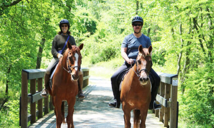
The McKeldin Area holds roughly 8.5 miles of trails and links up with other areas of the Patapsco Valley State Park. Trails are multi-use with some trails being off limits to horseback riders due to the rocky terrain or proximity to recreational areas such as campsites and the disc golf course.
The park charges a $2 per in-state vehicle and $3 per in-state person on weekends and holidays. The out-of-state fee is $4 per vehicle and $5 per person on weekends and holidays. Trailer parking is at the back of the park in a grassy area by the basketball courts and offers direct access to the Plantation and Tall Poplar trails.
Click here to download a trail map for McKeldin:patapsco_mckeldinmap
The Plantation Trail is 1.4 miles passing through a series of pine groves as well as running along one of the highest ridges in the McKeldin Area. Some portions of the trail can be steep. This trail also follows sections of the river.
The Tall Poplar Trail is also 1.4 miles and runs through the center of the park. The trail is named for the Poplar tree forest through which it runs. This trail has some moderately steep slopes and connects to the Switchback Trail.
The Switchback Trail is the longest loop in McKeldin and it covers 4 miles. The trail head is just below the entrance of the park. This trail mainly follows the river offering scenic views at the Liberty Dam Overlook at the end of the trail. Portions of the Switchback Trail are for foot traffic only so pay attention to trail markers along the way.
The 0.7-mile Rapids Trail starts at the southern end of the park, and can also be accessed from the Switchback Trail. The trail ends at the cascading rapids created where the Patapsco River flows into a large, deep pool of water that is a popular fishing spot. Swimming is strictly prohibited due to the strong undercurrents.
The Spring Glen Trail is a 0.7-mile loop that begins across from the entrance. It mainly follows the edge of a meadow and links up with the Switchback and Tall Popular trails.
Finally, the 0.3-mile Medicine Tree Trail begins at the youth camping field parking lot. This short loop is very rocky and includes crossing a bridge over a deep ravine.
In addition to the multi-use trails, McKeldin offers picnic shelters, youth camping, playgrounds, a basketball court and a disc golf course. Dogs are welcome but must be leashed at all times. There is no hunting allowed in the park, however fishing by permit is allowed.


